Norman residents should use the weekend to prepare for a round of severe weather expected Monday evening, Nov. 2, including the possibility of tornadoes.
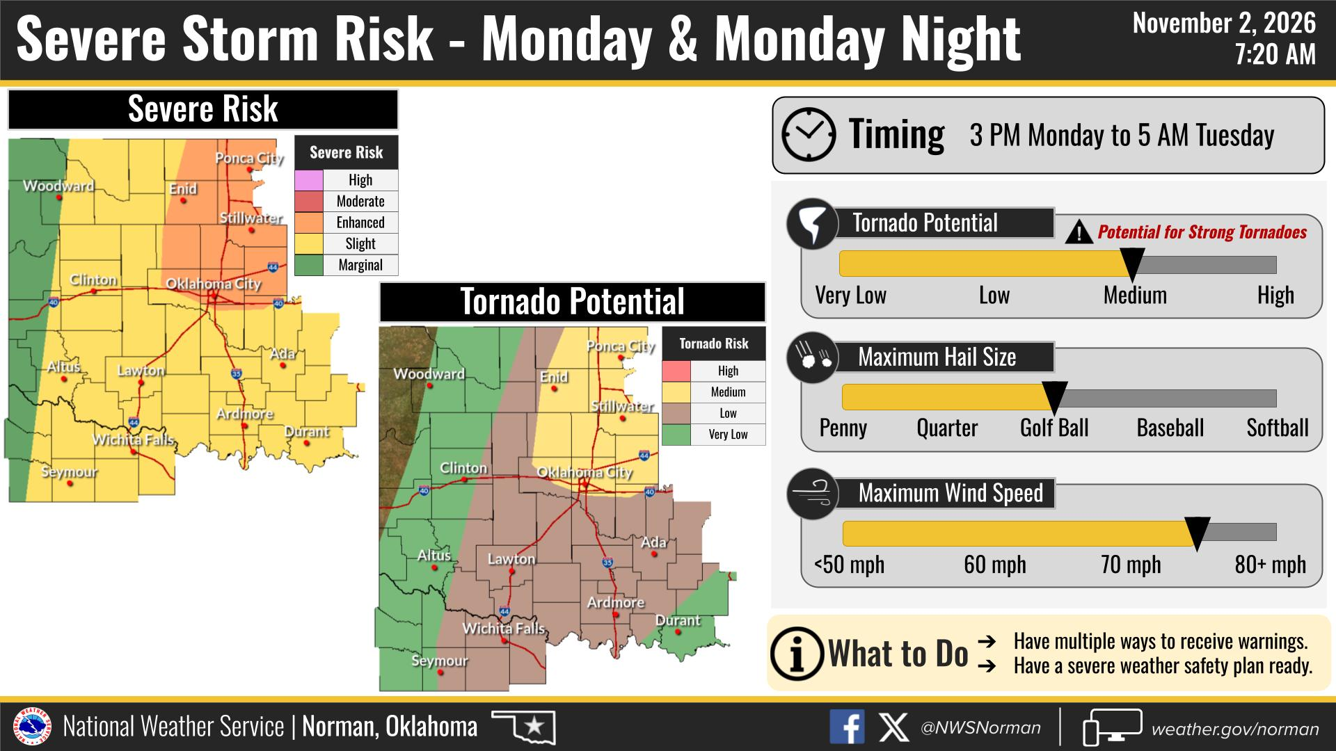
The National Weather Service office in Norman posted a "Severe Risk Late Monday" alert on its homepage Saturday morning. The agency said there is a slight risk of severe thunderstorms across Oklahoma and western north Texas on Monday, with the severe risk shifting over southeastern Oklahoma by late Monday night.
Strong to severe thunderstorms, along with locally heavy rainfall, are possible Monday into Tuesday morning, the NWS said.
What the Storm Prediction Center says
The Storm Prediction Center, based in Norman, issued its Day 3 Convective Outlook early Saturday. The outlook placed a slight risk of severe thunderstorms over parts of northern Texas and from western and central Oklahoma into southeast Kansas.
Damaging wind gusts are the main threat, according to the outlook. The SPC said scattered severe storms may develop across parts of the central to southern Plains on Monday from late afternoon into the evening.
The outlook also noted a possible tornado risk. The SPC said instability "will not be particularly strong, but sufficient to support wind damage, and perhaps a tornado risk" Monday evening. A low-level jet of up to 50 knots will support storm rotation, whether storms remain discrete or form into a line, the center said.
Storms are expected to begin over western Oklahoma near or just after sunset Monday, with increasing storm coverage through the evening as activity spreads across the state, according to the SPC discussion authored by forecaster Jewell.
Local meteorologists weigh in
KFOR meteorologist Mike Morgan wrote on Facebook on Friday, Oct. 30, that the OKC metro and I-35 corridor face a peak threat window of 7 p.m. to 10 p.m. Monday. Morgan said storms will begin west of Highway 81 during the mid-afternoon and move eastward.
Morgan pointed to an EF-3 tornado near Harrah in early November 2024 as a reminder that tornadoes can strike Oklahoma this time of year.
News 9 meteorologist Tom Pastrano also flagged Monday as a day to watch, posting on Facebook that severe storms will be possible Monday afternoon into the evening across parts of Oklahoma, with damaging winds, quarter-size hail and isolated tornadoes all possible.
Before the storms arrive
Saturday evening should be dry with temperatures in the 60s and light winds, according to the NWS. Sunday looks quiet, with mostly cloudy skies and a low of 64 degrees Sunday night.
Clocks fall back one hour early Sunday morning, Nov. 1, as daylight saving time ends. Monday's high in Norman is forecast at 78 degrees before storms move in.
The NWS said an active weather pattern will continue into next week with multiple chances for rain and thunderstorms beyond Monday.
Residents can monitor updates at weather.gov/oun or through the Storm Prediction Center at spc.noaa.gov.